A rank amateur in everything I write about. Do not rely on anything.
11 thoughts on “About”
Hello James – my research on Fitchett was fairly superficial and you’re right, there doesn’t seem to be much about his life outside the ODNB article (which has a short bibliography at the end). And Robert Roscoe seems positively elusive: I’m not even clear which “William Roscoe of Liverpool” was his father.
The Roscoe Papers 1514-23 in Liverpool RO has correspondence 1813-31 between William Roscoe and Fitchett. The National Archives catalogue lists some papers relating to Robert Roscoe which might be interesting. I’ll post here if I find anything else.
Hi! I was looking at some posts on your discussion about Fitchett’s King Alfred. I’m currently researching about Fitchett himself and was wondering whether you could point me to some sources to provide some more information on the very scant details currently in existence about his life, and his correspondence with Robert Roscoe. Thanks!
Thanks for your reply to my comment, sorry for the delay in responding! I did find out more info about the old rectory in Kingston Deverill from Julian Wiltshire the author of the book Kingston Deverill: A South West Wiltshire Village. I bought a copy of his book which is fascinating and has images and even the original plan drawings for the old rectory.
It turns out that Hugh Walpole stayed as a guest as a child at Kingston Deverill Rectory, and it was there that he first discovered Walter Scott on the bookshelves of the rectory, an author who influenced much of Walpole’s historical fiction work. I ended up putting some of the research gained from Julian on my website post at https://hughwalpole.com/where-did-hugh-walpole-live-a-guide-to-his-domestic-dwellings-literary-lodgings/ which features Kingston Deverill.
Thanks again for your additional information and links, very helpful, I shall continue investigating!
I was looking at K. Deverill from a bit before Walpole’s time and at a quick look all I’ve come up with is the location of the rectory. I can’t see how to post the screenshot here, but I think this link will take you straight there on the National Library of Scotland’s georeferenced maps (the map is interactive so you can zoom in and out. https://maps.nls.uk/geo/explore/#zoom=16.65591540372998&lat=51.13327&lon=-2.22033&layers=6&b=1
Hello, I found a post about Kingston Deverill on your website (I think from 2015). I’m searching for information about the rectory at Kingston Deverill for inclusion into a blog on my personal website about the writer Hugh Walpole. Hugh stayed at the Rectory in late 1890s during his holidays from Marlow school. Do you have any idea where I might be able to obtain the location of, or even a photograph of the rectory at Kingston Deverill, or if you might be able to point me in the direction of somewhere that could? Thanks and keep up the great work you do!
Hello, been trying to figure how to contact the person who the person is that produces the fascinating blog ‘Old Somerset’. Hopefully this works. I live in the village of Pawlett and been looking into the history of the village and see that you mention it in your blogs I wanted to repost some of the sections of you blog as a PDF but also wanted to give your blog full credit. Please message me back on how I could contact you directly to discuss this.
Hello Nick – A long time since I was working on Castrum Cynuit, in fact I could be done under the Trade Descriptions Act for calling the blog ‘Old Somerset’, since I’ve travelled round Wiltshire, Devon, Cornwall, Gloucestershire and a large chunk of the old Roman Empire … However, nothing wrong with loyalty to one’s home territory. Cannington is an interesting case: not a totally new suggestion and one I prefer to the scholars’ preference for Countisbury. The Danes, after all, did attempt a raid at the mouth of the Parrett. I think it had to be somewhere where the Danes could carry out a sudden raid.
Edington, Somerset, was accepted as a near certainty by some writers in the 19th c. and I did look at the possibility. Why would the defeated Guthrum be brought from Edington, Wiltshire, to be baptised at Aller? And thence to Wedmore? I even located an area called ‘Oakley’ (Achelai in Domesday) just south of Ilchester – for Acglea/Iglea. But trying to work out the possible manœuvrings of the two armies after the raid on Chippenham, I couldn’t make Edington, Somerset, work. Guthrum’s army seemed to be on the wrong side of Alfred’s, but maybe you can fathom that one out!
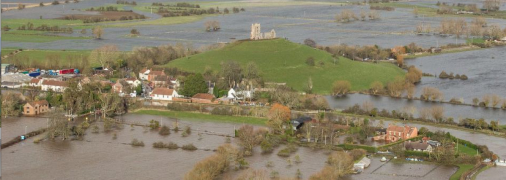
As for Brent Knoll, I think we have to stick with Athelney for the location of the burnt cakes. The earliest account (though not very early, maybe eleventh or twelfth century) that tells the story is clear that the event took place on Ethelingaige, the island of the nobles, in the salt marshes of Somerset.
The source documents – Asser and the Chronicle – are fairly terse. They leave considerable room for doubt about the locations of Alfred’s hiding place, Cynuit, Egbert’s Stone, Iley Oak, and the Battle of Ethandun (aka Edington).
It now seems to be accepted that the hiding place was at Athelney on the Somerset levels.
The argument that Edington was in Wiltshire seems to be largely based on the fact that Alfred left some land there in his Will. Which doesn’t seem to me to be good reasoning.
I wish to pencil in a suggestion that Cynuit was the location now known as “Cannington Castle”. An old Roman site, on the River Parrett. Near (2 miles at most) a harbour now called Combwich (pronounced Cummich).
It is close to the Roman Road across the Poldens – a couple of miles if you are prepared to for the Parrett. Also within about 16 miles of Athelney (by todays main roads).
I also suggest that Ethandun is Edington in Somerset. This is less than 10 miles from Athelney; less than 10 from Cynuit/Cannington; less than 10 from Wedmore, where the Treaty was signed; two or three from Aller (Guthrum was baptised there). There is a site on the ridge of the Poldens, overlooking Athelney, and on the Roman Road that runs from the River Parrett north east towards Bath (and so Chippenham). Between Edington and Egbert’s stone, the route might take one to Ilminster and Ilchester (as Iley Oak).
I accept that these men routinely marched considerable distances.
I can see that the meeting at Egbert’s stone was at least 30 miles away.
I acknowledge that they went to Chippenham, which is at least 45 miles away, between the battle and the Treaty.
Another weakness in my theory is that there is no evidence of Danes in Somerset. But this does not prove that they weren’t here either.
Finally I acknowledge my own loyalty to Somerset – and proximity to Edington.
But I think that the Will is a weak argument; and I think that proximity is a stronger one. The routeways (such as we can envisage today) add weight. And I note the suggestion that the Danes were in strength on the ridge of the Poldens – possibly gathering troops from Chippenham together with troops from Cannington.
My theory also allows for the romantic possibility that Alfred was on Brent Knoll when he burned the cakes – watching his men carry out the raid at Cynuit/Cannington across the river.
A look at the ground on the sites I mention adds value to my theory.
Dear Sir
Many thanks for the very quick and informative reply. I too came accross your website when I was looking for any info. on the altar.
Kind regards
Bill
Very wise of you not to wade through the long-drawn out and pedantic arguments! I’ve approached the question from the literary/historical angle, with archaeology being dragged in, as and where I found evidence, to support my case. So I’m not even an amateur archaeologist. The Romans have barely featured because there is little sign that they reached this area of Exmoor and north Devon: a couple of fortlets near the coast are supposed to have served as watch-out posts for marauding/invading Silures from south Wales, but nothing intended for permanent settlement. It’s been a direct leap here from the British/Welsh/Celts (Dumnonii) straight to the Anglo-Saxons, particularly under Egbert, who were determined to push as far west as possible.
I came upon Piercebridge because I was investigating the origin of the name ‘Countisbury’ if not the historians’ assumed ‘Cynuit’. The East Lyn had two separate confluences surrounding the Iron Age hillfort and that led me to discover ‘Condatis’ the Celtic god of confluences: hence to the Roman altar at Piercebridge (and Condate as the Roman name for Northwich).
As for Roman canals, it might be something to investigate further north, on the Somerset Levels where the Romans had a port (possibly two – at Combwich and at Crandon Bridge) and there was much Roman settlement on the uplands. Did they build canals? I don’t know of any archaeological evidence, but canals and drainage ditches or ‘rhynes’ have been built since then. Travel and transportation across the Levels were needed from Neolithic times (which is when the Sweet Track was built) but the Romans seem to have mainly relied on roads. Plenty of Roman roads across the Poldens and Mendips where they were mining lead, but these may have been too close to the natural rivers to need canals as well (my totally uneducated opinion).
As for the Exmoor terrain, my early theory that the Vikings might have reached land at Lynmouth and sailed up the East Lyn river had to be quickly abandoned: no longships would have climbed up the steep rocky river with its waterfalls. Canals would therefore have been unlikely too.
Hi
Without reading the full story of Somerset and some of your comments could I make the following comment. I am an amaetur archaeologist and have been investigating the possibility of the Roman’s supplying Piercebridge by river or canal. This had led me to carrying out excavations in a strange “ditch” at High Coniscliffe where the Roman altar was found in 1709. The altar description condate relating to a Roman surveyer could point to this ditch being the remains of a canal. The research is an attempt to prove the controversial Piercebridge Formula on Roman navigation was a true interpretation of the Roman Dam/Bridge site at Piercebridge. In that respect is the Somerset levels a site also for Roman navigation. The excavations in the ditch could not prove a canal but it is too small to take the River Tees and cuts cleanly through higher ground. Do you have any comments please on Roman navigation.
Kind regards
Bill Trow
Northern Archaeology Group.

Hello James – my research on Fitchett was fairly superficial and you’re right, there doesn’t seem to be much about his life outside the ODNB article (which has a short bibliography at the end). And Robert Roscoe seems positively elusive: I’m not even clear which “William Roscoe of Liverpool” was his father.
The Roscoe Papers 1514-23 in Liverpool RO has correspondence 1813-31 between William Roscoe and Fitchett. The National Archives catalogue lists some papers relating to Robert Roscoe which might be interesting. I’ll post here if I find anything else.
LikeLike
Hi! I was looking at some posts on your discussion about Fitchett’s King Alfred. I’m currently researching about Fitchett himself and was wondering whether you could point me to some sources to provide some more information on the very scant details currently in existence about his life, and his correspondence with Robert Roscoe. Thanks!
LikeLiked by 1 person
Thanks for your reply to my comment, sorry for the delay in responding! I did find out more info about the old rectory in Kingston Deverill from Julian Wiltshire the author of the book Kingston Deverill: A South West Wiltshire Village. I bought a copy of his book which is fascinating and has images and even the original plan drawings for the old rectory.
It turns out that Hugh Walpole stayed as a guest as a child at Kingston Deverill Rectory, and it was there that he first discovered Walter Scott on the bookshelves of the rectory, an author who influenced much of Walpole’s historical fiction work. I ended up putting some of the research gained from Julian on my website post at https://hughwalpole.com/where-did-hugh-walpole-live-a-guide-to-his-domestic-dwellings-literary-lodgings/ which features Kingston Deverill.
Thanks again for your additional information and links, very helpful, I shall continue investigating!
Seasons greetings,
Simon Dunant
https://hughwalpole.com
LikeLike
Hello Simon,
I was looking at K. Deverill from a bit before Walpole’s time and at a quick look all I’ve come up with is the location of the rectory. I can’t see how to post the screenshot here, but I think this link will take you straight there on the National Library of Scotland’s georeferenced maps (the map is interactive so you can zoom in and out.
https://maps.nls.uk/geo/explore/#zoom=16.65591540372998&lat=51.13327&lon=-2.22033&layers=6&b=1
As I read it on the Listed Buildings website, Kingston House (holiday apartments) is what was the rectory; unfortunately no photo, though:
https://britishlistedbuildings.co.uk/101036402-kingston-house-kingston-deverill#.YSvEy8bTU_U
Also at BA12 7HE I can see on Google Street map a building that looks as if it could have been the rectory. Might be worth exploring?
LikeLike
Hello, I found a post about Kingston Deverill on your website (I think from 2015). I’m searching for information about the rectory at Kingston Deverill for inclusion into a blog on my personal website about the writer Hugh Walpole. Hugh stayed at the Rectory in late 1890s during his holidays from Marlow school. Do you have any idea where I might be able to obtain the location of, or even a photograph of the rectory at Kingston Deverill, or if you might be able to point me in the direction of somewhere that could? Thanks and keep up the great work you do!
Simon Dunant
hughwalpole.com
LikeLike
Hello, been trying to figure how to contact the person who the person is that produces the fascinating blog ‘Old Somerset’. Hopefully this works. I live in the village of Pawlett and been looking into the history of the village and see that you mention it in your blogs I wanted to repost some of the sections of you blog as a PDF but also wanted to give your blog full credit. Please message me back on how I could contact you directly to discuss this.
LikeLike
Hello Nick – A long time since I was working on Castrum Cynuit, in fact I could be done under the Trade Descriptions Act for calling the blog ‘Old Somerset’, since I’ve travelled round Wiltshire, Devon, Cornwall, Gloucestershire and a large chunk of the old Roman Empire … However, nothing wrong with loyalty to one’s home territory. Cannington is an interesting case: not a totally new suggestion and one I prefer to the scholars’ preference for Countisbury. The Danes, after all, did attempt a raid at the mouth of the Parrett. I think it had to be somewhere where the Danes could carry out a sudden raid.
Edington, Somerset, was accepted as a near certainty by some writers in the 19th c. and I did look at the possibility. Why would the defeated Guthrum be brought from Edington, Wiltshire, to be baptised at Aller? And thence to Wedmore? I even located an area called ‘Oakley’ (Achelai in Domesday) just south of Ilchester – for Acglea/Iglea. But trying to work out the possible manœuvrings of the two armies after the raid on Chippenham, I couldn’t make Edington, Somerset, work. Guthrum’s army seemed to be on the wrong side of Alfred’s, but maybe you can fathom that one out!
As for Brent Knoll, I think we have to stick with Athelney for the location of the burnt cakes. The earliest account (though not very early, maybe eleventh or twelfth century) that tells the story is clear that the event took place on Ethelingaige, the island of the nobles, in the salt marshes of Somerset.
LikeLike
The source documents – Asser and the Chronicle – are fairly terse. They leave considerable room for doubt about the locations of Alfred’s hiding place, Cynuit, Egbert’s Stone, Iley Oak, and the Battle of Ethandun (aka Edington).
It now seems to be accepted that the hiding place was at Athelney on the Somerset levels.
The argument that Edington was in Wiltshire seems to be largely based on the fact that Alfred left some land there in his Will. Which doesn’t seem to me to be good reasoning.
I wish to pencil in a suggestion that Cynuit was the location now known as “Cannington Castle”. An old Roman site, on the River Parrett. Near (2 miles at most) a harbour now called Combwich (pronounced Cummich).
It is close to the Roman Road across the Poldens – a couple of miles if you are prepared to for the Parrett. Also within about 16 miles of Athelney (by todays main roads).
I also suggest that Ethandun is Edington in Somerset. This is less than 10 miles from Athelney; less than 10 from Cynuit/Cannington; less than 10 from Wedmore, where the Treaty was signed; two or three from Aller (Guthrum was baptised there). There is a site on the ridge of the Poldens, overlooking Athelney, and on the Roman Road that runs from the River Parrett north east towards Bath (and so Chippenham). Between Edington and Egbert’s stone, the route might take one to Ilminster and Ilchester (as Iley Oak).
I accept that these men routinely marched considerable distances.
I can see that the meeting at Egbert’s stone was at least 30 miles away.
I acknowledge that they went to Chippenham, which is at least 45 miles away, between the battle and the Treaty.
Another weakness in my theory is that there is no evidence of Danes in Somerset. But this does not prove that they weren’t here either.
Finally I acknowledge my own loyalty to Somerset – and proximity to Edington.
But I think that the Will is a weak argument; and I think that proximity is a stronger one. The routeways (such as we can envisage today) add weight. And I note the suggestion that the Danes were in strength on the ridge of the Poldens – possibly gathering troops from Chippenham together with troops from Cannington.
My theory also allows for the romantic possibility that Alfred was on Brent Knoll when he burned the cakes – watching his men carry out the raid at Cynuit/Cannington across the river.
A look at the ground on the sites I mention adds value to my theory.
LikeLike
Dear Sir
Many thanks for the very quick and informative reply. I too came accross your website when I was looking for any info. on the altar.
Kind regards
Bill
LikeLike
Hello Bill,
Very wise of you not to wade through the long-drawn out and pedantic arguments! I’ve approached the question from the literary/historical angle, with archaeology being dragged in, as and where I found evidence, to support my case. So I’m not even an amateur archaeologist. The Romans have barely featured because there is little sign that they reached this area of Exmoor and north Devon: a couple of fortlets near the coast are supposed to have served as watch-out posts for marauding/invading Silures from south Wales, but nothing intended for permanent settlement. It’s been a direct leap here from the British/Welsh/Celts (Dumnonii) straight to the Anglo-Saxons, particularly under Egbert, who were determined to push as far west as possible.
I came upon Piercebridge because I was investigating the origin of the name ‘Countisbury’ if not the historians’ assumed ‘Cynuit’. The East Lyn had two separate confluences surrounding the Iron Age hillfort and that led me to discover ‘Condatis’ the Celtic god of confluences: hence to the Roman altar at Piercebridge (and Condate as the Roman name for Northwich).
As for Roman canals, it might be something to investigate further north, on the Somerset Levels where the Romans had a port (possibly two – at Combwich and at Crandon Bridge) and there was much Roman settlement on the uplands. Did they build canals? I don’t know of any archaeological evidence, but canals and drainage ditches or ‘rhynes’ have been built since then. Travel and transportation across the Levels were needed from Neolithic times (which is when the Sweet Track was built) but the Romans seem to have mainly relied on roads. Plenty of Roman roads across the Poldens and Mendips where they were mining lead, but these may have been too close to the natural rivers to need canals as well (my totally uneducated opinion).
As for the Exmoor terrain, my early theory that the Vikings might have reached land at Lynmouth and sailed up the East Lyn river had to be quickly abandoned: no longships would have climbed up the steep rocky river with its waterfalls. Canals would therefore have been unlikely too.
LikeLike
Hi
Without reading the full story of Somerset and some of your comments could I make the following comment. I am an amaetur archaeologist and have been investigating the possibility of the Roman’s supplying Piercebridge by river or canal. This had led me to carrying out excavations in a strange “ditch” at High Coniscliffe where the Roman altar was found in 1709. The altar description condate relating to a Roman surveyer could point to this ditch being the remains of a canal. The research is an attempt to prove the controversial Piercebridge Formula on Roman navigation was a true interpretation of the Roman Dam/Bridge site at Piercebridge. In that respect is the Somerset levels a site also for Roman navigation. The excavations in the ditch could not prove a canal but it is too small to take the River Tees and cuts cleanly through higher ground. Do you have any comments please on Roman navigation.
Kind regards
Bill Trow
Northern Archaeology Group.
LikeLike