I’ve started this blog four times already and got stuck each time, so here’s the fifth attempt (Part 1). Thanks to ‘Dusty’ for the Christian Marx article on Ptolemy: the maths looks a bit complicated but the maps resemble the ones I drew up. A bit.
Belgae: There’s general agreement that they weren’t a separate tribe but a loose ‘confederation’ of tribes. If you look at the maps showing the tribes of Roman Gaul, there are no ‘Belgae’, just various tribes who occupied Gallia Belgica; so the likelihood is (I presume) that the ‘Belgae’ of Roman Britannia designated a grouping made up of neighbouring tribes from north east Gaul distinguished as being the last Celtic migration, which arrived during the first century BC. They were as a group culturally distinctive enough for archaeologists to identify certain artifacts, including coins, as ‘Belgic’.
Some authorities, like Wacher, confine the tribe in an area roughly corresponding to southern Hampshire, which tallies with Winchester – Venta Belgarum – being the capital of their civitas, the administrative area set up by the Romans. The Atrebates to the north, with their capital at Silchester – Calleva Atebatum – may have been closely connected, and also the Reg(i)ni to the east. All ‘Belgae’ in the loose sense.
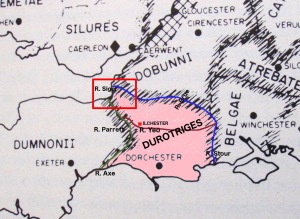
According to this theory, the neighbouring Durotriges, centred on Dorchester (Durnovaria), hypothetically spread up through Dorset to reach the Somerset coast somewhere between the mouth of the River Parrett and Brean Down. We know that Ilchester (Lindinis or Lendiniae) in east Somerset was held by the Durotriges in the 4th century and was possibly the πόλις of a separate northern division of the civitas Durotrigum because inscriptions have been found at – of all places – Hadrian’s Wall which refer to ‘C(ivitas) Dur(o)tr(i)g(um) [L]endin(i)e(n)sis’. This indicates that men from Lendiniae helped with repair work on the wall. The inscription is dated AD 369:
Meanwhile, other authorities (including Oppenheimer) have the Belgae spreading north west through Dorset and reaching the Somerset coast, at that same point – that is, between the mouth of the Parrett and Brean Down. If that is correct, the civitas Belgarum might just have included Aque Calide (Bath), as Ptolemy said, as well as the mysterious ‘Iscalis’, a little further to the west of Bath.
However, I haven’t found (as yet) any primary evidence that they reached this far, other than the charts drawn up from Ptolemy’s coordinates; and Ptolemy could have been mistaken, or the surviving medieval manuscript sources could have mistranscribed. Ptolemy appears to be the sole evidence for their presence in north Somerset (correct me if I’m wrong), and the modern sources derive directly from him (wisely or unwisely).
The evidence seems to be stronger that Bath was a centre of the Dobunni who spread down through Gloucestershire as far south as the Mendips, with their civitas capital at Corinium (Cirencester). Bath was obviously an important centre for Celts as well as the Romans, Aquae Sulis being named after the Celtic deity Sulis (Minerva); but the administrative status of Bath isn’t known.
Having examined these options, I shall next look more closely at the geography of this part of Somerset in light of these alternative theories. Quite soon before I forget what I wanted to say.


Heh, heh 🙂 Other people watch television of an evening (I’m not allowed to do that even on Catch Up now): scholarship may [sic] benefit.
LikeLike
Way to go, Old Somerset!
LikeLiked by 1 person