A round-up of achievement

This blog has now succeeded in solving a number of historical puzzles to the complete satisfaction of absolutely no-one.

1. Asser’s Arx Cynuit: not Countisbury (scholars), and certainly not the west coast of Devon (romantics). The height of the sheer north Devon cliffs seemed to preclude either landing ships or climbing to reach the supposed encampment at Countisbury; and there is no early evidence of any kind for the area around Appledore, favoured as it is by its local historians – and promoted by antiquarians. More likely than either of these is the area to the east of Countisbury, where there are no cliffs, where there were several, well-attested Viking attacks and where there were richer pickings for lightning raiders. Likelihood 7/10.  However, if the Danes had landed here, might they have chased the thegns for ten miles along the north Devon coast to Countisbury? If so, one thing that could support Countisbury is the very fact that the camp was remote, probably abandoned, and thus a refuge of last resort and a good place to besiege trapped enemies.   (A hypothesis that the arx itself might have been at Watersmeet was ‘proposed, considered and finally rejected’.)

2. Ptolemy’s Iscalis: not Charterhouse-on-Mendip (scholars), the centre of the Roman lead-mining industry, but somewhere to the south west, near the mouth of the river Parrett – a noteably watery region – where there are plentiful signs of Roman settlement and a salt-mining industry. It is conveniently placed with Roman ports at Combwich and Crandon Bridge. All that’s missing is any sign of a town comparable in size to Charterhouse, though much is possibly hidden beneath the M5.

The main Roman settlement is underneath the M5 interchange, 2km from the Roman port at Crandon Bridge

There are also signs of early British settlement (the lake village at West Huntspill, for example) which could explain why, according to Ptolemy, it was made a tribal centre in the Roman era. Likelihood 7/10.

3. The Antonine Itinerary’s Traiectus: not Bitton (thus scholars and just about everyone else), but slightly further west in the area south from Willsbridge, over to Keynsham on the other side of the Avon. There are abundant Roman remains at Keynsham and a ‘traiectus’, over the river from the Abona to Aquae Sulis Roman road. A north-south Roman road meeting the east-west road, for which there is slight evidence, would strengthen the case. Likelihood 8/10

4. And, right at the beginning, there was King Alfred’s æstel. The scholars are agreed it was a stick, or pointer, used by Saxon monks to keep their place when reading their manuscripts, to follow the text as they read it; and that the Alfred Jewel and a few similar artefacts were fixed to the top of such æstels. The drawback is that, although such sticks, or pointers, ought to exist, there seems no evidence that they actually did. Where are they mentioned? Where are they depicted in illuminations of monks reading their manuscripts? So, not a reader’s stick or pointer; but an alternative suggestion is that the jewels were fixed to the top of bookmarks, which, as Alfred directed, were to be kept in the bound volumes. The Latin translation indicatorium could as easily indicate a page or opening in the manuscript, rather than the exact place on the page. Likelihood 4/10

Done. So where next?

Others here before me

There has been quite a lot of interest in the tribal grouping which the Romans referred to as the Durotriges – most notably, recently, among the Bournemouth University archaeologists who have been uncovering the Iron Age ‘town’ at Winterborne Kingston, on the Icknield Way, and which they’ve nicknamed ‘Duropolis’. This has proved to be one of the largest such settlements yet found in Britain,  an ‘open settlement’ rather than an occupied hillfort.

Others have been examining the Durotrigan coin finds. I have ‘refined’ a map in Costen’s Origins of Somerset  which suggests that they made their way further west than Dorset, most probably to the Severn estuary coast.

I have guessed at the intended locations of the Durotrigan coin finds: the territory of the three tribes was estimated by Costen, but is similar to Wacher, The Towns of Roman Britain

I have guessed at the intended locations of the Durotrigan coin finds (names with queries): the territory of the three tribes was estimated by Costen, but is similar to Wacher, The Towns of Roman Britain

I suppose the coin locations could just indicate trading activity, but it seems unlikely that any other tribe (e.g. the Belgae) would have occupied the western Levels, squeezing between the Dobunni and the Durotriges (while leaving little or no evidence of their presence). But somebody was there because the Iron Age relics are abundant.

So Ptolemy, writing c. 150AD, was indeed a little adrift when he grouped Iscalis, Bath and Winchester together as towns of the Belgae. Bath was almostly certainly a Dobunnic town, Winchester was definitely in the territory of the Belgae. Which leaves the mysterious Iscalis – certainly not a settlement of the Belgae; just possibly of the Dobunni, if it was Charterhouse on Mendip or near the course of the old River Axe.

However, if the Durotriges were the grouping which reached the Severn estuary, it’s strange that Ptolemy gave them only one town: Dunium (presumed to be Hod Hill). They would surely have had a town somewhere further west than east Dorset (Ilchester is presumed by those who know better than me/I to have gained its importance at a later date).

Blue squares mark old course of the Parrett, following part of the King's Sedgemoor drain and rejoining the river at Horsey Pill. Crandon Bridge and Bawdrip circled.

The blue squares mark the old course of the Parrett, following part of the King’s Sedgemoor drain to the north and rejoining the River Parrett at Horsey Pill. Crandon Bridge and Bawdrip circled.

But, in the way that it does, the internet seems to have spread the word – before me – that Bawdrip, in Somerset, was a possible location. There was a single common source for all  these  references because they place Bawdrip on the River Axe.

It isn’t now and wasn’t then: it’s close to a now silted up meander in the River Parrett, some 10 miles south of the Axe – and in the area singled out as one of the most heavily Romanised areas of Somerset. If Iscalis wasn’t actually Burnham-on-Sea and wasn’t actually Bawdrip, it could well have been somewhere near this Romanised, watery place. Iscalis by name and Iscalis by nature.

Really? Burnham-on-Sea is Iscalis?

Well, no, probably not Burnham exactly. But as near as makes no difference. Let’s look at the area of interest, between the Axe and the Parrett:

The watery side of Somerset

The Somerset Levels at the time of the Roman Occupation

The question is first – are there signs of Iron Age occupation (never mind whether they were Belgae, Durotriges, Dobunni or Dumnonii)? For a start, there are the places ringed in red.

On the right, the lake settlements – the ‘villages’ at Meare and Godney (aka Glastonbury Lake Village). On the left, half off the diagram, is Cannington hillfort: it’s south of the Parrett, so can be ignored for these purposes; towards the top is the large multivallate hillfort on Brent Knoll.

On the coast, below Burnham is Alstone – the site of another lake settlement which hasn’t been fully investigated, but was certainly inhabited during the Roman period. The ‘island’ stands, geologically speaking, on a ‘Burtle bed’ – a slightly raised area set on clay, covered with an accumulation of sand and gravel. Geologists can’t agree whether these were formed during an ice age or whether tidal waters washed up the debris. The eponymous ‘Burtle’ is a small village set on a similar bed, shown on the diagram above, south of Wedmore, north of the Poldens and to the west of Meare and Godney.

It’s tempting to see Westhay, Meare and Godney as similar structures, set in a line with Alstone and Burtle, but in fact they appear to be geologically different.

My feeling was that Iscalis had to be in an area occupied by Celts and Romans. The Iron Age archaeological sites aren’t limited to the ones I’ve mentioned: but what about the Romans?

There were four main areas of heavy Romanisation in this part of Somerset: three were around Ilchester, stretching along the Poldens to Compton Dundon; around Bath and along the Avon to Sea Mills – Portus Abonae; and the western section of the Mendips, around Charterhouse and the lead mines.

A fourth area was the one marked in the diagram above with the blue outline. Here the signs of Roman occupation are abundant. Why? Forget about lead-mining: this was a major centre of Roman salt production. What would be good to find here is an  area of Roman occupation similar in extent to Lendeniae, Aquae Sulis (Calidae), Corinium and Isca Dumnoniorum – quality rather than quantity – and this may be a bit more difficult.

This watery place

Looking at the geography of Somerset at the point where the three (perhaps four) Celtic tribal groupings would have met, it turns out that there is no shortage of watery places. But a main ‘civitas’ πόλις  would have signs of British and Roman occupation of some description – presumably – because the Romans wouldn’t simply have designated an undeveloped Iron Age hillfort and expected that to be some sort of administrative centre. Their own custom was to build their cities close to where the tribal centres had been.

No Man's Land?

No Man’s Land?

The blue rectangle is roughly, give or take, where No Man’s Land was. The southern line is just below the mouth of the Parrett (the supposed limit of the territory of the Dumnonii) and passes just north of Ilchester, in Durotrigan territory. To the north, the boundary lies just north of the Axe – one estimated boundary of the Dobunni – and passes eastwards over the Mendips.

It’s a fascinating area: Brean Down, with its Romano-British temple and possibly a small port; Charterhouse Roman Town, a centre of Iron Age and Roman lead mining; the small Roman port of Rackley on the Axe and, a little further along, Cheddar where there may also have been a port; just north of the Poldens, the two Iron Age lake villages of Meare and Glastonbury; the Roman ports at Combwich and Crandon Bridge on the Parrett; and Ilchester itself, traditionally identified with Iscalis, at the centre of a network of Roman roads – the Fosseway going north and south, the road to Dorchester and a smaller road along the Poldens, perhaps to Crandon Bridge.

Another suggested site lies to the north of the Mendips: Gatcombe, in Long Ashton. There was a Roman settlement here of unknown extent, of which Professor Cunliffe says:

“If it were a settlement of any size it would be tempting to equate it with the place called Iscalis by Ptolemy, which according to him lay to the west of Aquae Calidae (Bath). To suppose that Iscalis was Gatcombe would be as reasonable as any of the other situations proposed for it …”  (‘Excavations at Gatcombe, Somerset, in 1965 and 1966’, Proceedings, University of Bristol Spelæological Society, 11-2 pp 126-160).

I’m not sure it’s ‘as reasonable’ as any of the others: Professor Cunliffe estimated the Dobunni were settled as far south as the River Axe, and Gatcombe would therefore have been in their territory, not that of the Belgae. But, if there was such a place as Iscalis – not 100% certain, it’s hard to see a place in any of the known tribal territories that would fit it.

According to Ptolemy in the 2nd century, the Dumnonii had four πόλεις – Voliba, Uxella, Tamara and Isca Dumnoniorum; the Durotriges had one – Dunium, though Durnovaria and Lendeniae also had some significance at some point. For the Dobunni, only Corinium was named, though there is speculation that they had a more southerly division. And the Belgae: the term seems to be used for a later wave of migrants from various tribes, but it’s unlikely that they would have established themselves so far west by the 2nd century, when Ptolemy was writing.

What would I guess? Well. Of course. Iscalis was … Burnham-on-Sea  :-).

More follows …

A brief recapitulation

I have been unable to find any primary reference to Iscalis other than in Ptolemy’s Geographia: all later references derive from Ptolemy. The original was in Greek and I don’t know how the name was spelled as I can’t find a Greek text (of which the earliest manuscript is 13th c.)

The (2nd c.) Antonine Itinerary didn’t cover this area. William Stukeley’s 18th c. ‘reconstruction’ marked the Fosseway, and Ilchester as ‘Ischalis’ – the common identification at the time; but there is no Iter along the Fosseway in the original, so this is Stukeley’s addition. The nearest Iter is XV which goes through Winchester, Salisbury and Dorchester to end up at Exeter.

The Stukeley reconstruction

The Stukeley reconstruction, in which Ischalis = Ilchester

The Ravenna Cosmography also does not mention it so Ptolemy, c. 150 AD, appears to be the only early source.

The only other point of information (or more probably misinformation) was that it was one of the πόλεις of the Belgae, along with Venta Belgarum and Aque Calide. And, according to Ptolemy’s method, it was situated west of Aque Calide (Bath). One difficulty is that the territory of the Belgae almost certainly didn’t extend even as far as Bath, still less further west to ‘Iscalis’. Another suggestion (Francis Haverfield in the Somerset Victoria County History, 1906) is that it was no more than a mistake, perhaps a confusion with Isca Silurum, modern-day Caerleon.

If we discount the supposition that the town may not have existed at all, and if it did it wasn’t in the territory of the Belgae, we can say that it was in Somerset, probably in the area where the territories of Dobunni, Dumnonii and Durotriges met – the No Man’s Land. It also seems an irresistible conclusion that the name is related to the British isca, meaning ‘water’? (rather than ‘a river’ – afon – Abona). So we have a Romanised/Latin name with an adjectival suffix that suggests ‘a watery place’.

So, what manner of place was No Man’s Land at the time of the Romans?

The geography of the place

Cunliffe: Estimated territory of the Dobunni

B. Cunliffe (1991): Estimated territory of the Dobunni

So, to the north, the Dobunni, with Corinium (Cirencester) their civitas capital. It’s supposed that they spread down into Somerset as far as the Mendips. For Professor Cunliffe, judging by Iron Age pottery and coin finds, the River Axe was the estimated southern boundary (1).

In that case Bath would have been in their region (rather than the Belgae) at least during the Iron Age, and Professor Cunliffe suggested that there might have been a ‘southern splinter group’  at a later date (Ptolemy was writing c. 150AD), like the one around Ilchester for the Durotriges. Bath would then possibly have been the ‘sub-capital’ though there is no evidence for this.

So far, so … probable/possible.

To the south west were the Dumnonii in Cornwall, Devon and west Somerset, with their civitas capital Isca Dumnoniorum (Exeter). Their northern boundary seems to have extended as far as the River Parrett.

To the south east are the Durotriges, civitas capital given as Dunium by Ptolemy which scholars seem happy to identify with Hod Hill, a hillfort about 4 miles north of Blandford Forum. Why this is preferred (if they were going to choose a hillfort) over Maiden Castle just a stone’s throw south west of Dorchester, I don’t know – perhaps there are more traces of sub-Roman civilian habitation;  but Ilchester – Lendiniae – was certainly part of the Durotrigan territory in the 4th century and was the most north westerly centre. Ham Hill and South Cadbury are both described as ‘Durotrigan’ at some point. Hengistbury Head on the south coast, where the Stour and the Avon reach the sea at Christchurch, was an important trading centre with a mint and is another suggested site tribal centre.

This leaves the Belgae. Using circles to show the (very rough) possible settlements of the four tribal groups, as discussed:

Circles don't accurately show likely geographical boundaries

Circles don’t accurately show likely geographical boundaries: ellipses would have been a bit better

We know where the River Parrett was, we know where Ilchester/Lendeniae was, we know where the Mendips and River Axe were. This leaves a kind of No Man’s Land in the centre. Did the Durotriges – or the Belgae – get to the Somerset coast in the 1st-2nd century AD? Ptolemy thought the Belgae. At any rate, that No Man’s Land is worth looking at next.

(1).B.Cunliffe, Iron Age Communities in Britain: an account of England, Scotland and Wales from the seventh century BC to the Roman conquest 3rd edn (1991), pp.170-5. Referenced on a website about Saxon Bath.

So, where were the Belgae? (1)

I’ve started this blog four times already and got stuck each time, so here’s the fifth attempt (Part 1). Thanks to ‘Dusty’ for the Christian Marx article on Ptolemy: the maths looks a bit complicated but the maps resemble the ones I drew up. A bit.

Belgae: There’s general agreement that they weren’t a separate tribe but a loose ‘confederation’ of tribes. If you look at the maps showing the tribes of Roman Gaul, there are no ‘Belgae’, just various tribes who occupied Gallia Belgica; so the likelihood is (I presume) that the ‘Belgae’ of Roman Britannia designated a grouping made up of neighbouring tribes from north east Gaul distinguished as being the last Celtic migration, which arrived during the first century BC. They were as a group culturally distinctive enough for archaeologists to identify certain artifacts, including coins, as ‘Belgic’.

Wacher's hypothetical civitas Durotrigum

J. Wacher (1974): hypothetical civitas Durotrigum, the Belgae to the east

Some authorities, like Wacher, confine the tribe in an area roughly corresponding to southern Hampshire, which tallies with Winchester – Venta Belgarum – being the capital of their civitas, the administrative area set up by the Romans. The Atrebates to the north, with their capital at Silchester – Calleva Atebatum – may have been closely connected, and also the Reg(i)ni to the east. All ‘Belgae’ in the loose sense.

According to this theory, the neighbouring Durotriges, centred on Dorchester (Durnovaria), hypothetically spread up through Dorset to reach the Somerset coast somewhere between the mouth of the River Parrett and Brean Down. We know that  Ilchester (Lindinis or Lendiniae) in east Somerset was held by the Durotriges in the 4th century and was possibly  the πόλις of a separate northern division of the civitas Durotrigum because inscriptions have been found at – of all places – Hadrian’s Wall which refer to ‘C(ivitas) Dur(o)tr(i)g(um) [L]endin(i)e(n)sis’. This indicates that men from Lendiniae helped with repair work on the wall. The inscription is dated AD 369:

Oppenheimer (2006): Tribes of northern Gaul

S. Oppenheimer (2006): Tribes of northern Gaul

Meanwhile, other authorities (including Oppenheimer) have the Belgae spreading north west through Dorset and reaching the Somerset coast, at that same point – that is, between the mouth of the Parrett and Brean Down. If that is correct, the civitas Belgarum might just have included Aque Calide (Bath), as Ptolemy said, as well as the mysterious ‘Iscalis’, a little further to the west of Bath.

However, I haven’t found (as yet) any primary evidence that they reached this far, other than the charts drawn up from Ptolemy’s coordinates; and Ptolemy could have been mistaken, or the surviving medieval manuscript sources could have mistranscribed. Ptolemy appears to be the sole evidence for their presence in north Somerset (correct me if I’m wrong), and the modern sources derive directly from him (wisely or unwisely).

The evidence seems to be stronger that Bath was a centre of the Dobunni who spread down through Gloucestershire as far south as the Mendips, with their civitas capital at Corinium (Cirencester). Bath was obviously an important centre for Celts as well as the Romans, Aquae Sulis being named after the Celtic deity Sulis (Minerva); but the administrative status of Bath isn’t known.

Having examined these options, I shall next look more closely at the geography of this part of Somerset in light of these alternative theories. Quite soon before I forget what I wanted to say.

Not very accurate

I’ve been looking at Ptolemy’s information on the island of Britannia and have constructed a version of the southern part of England based on his coordinates. Whether it’s oriented correctly or whether it should be tilted slightly doesn’t matter for the moment. Some of his geographic locations (as far as they’ve been identified) are obviously wide of the mark; but, notwithstanding that there may have been a number of inaccuracies introduced between Ptolemy’s time and the late medieval copies that we have, some of it must have been at least what he intended – even if not necessarily accurate.

This is my rough (all right, very rough) map, with a few speculations, based on his latitude and longitudes:

Named map1

And just for a bit of fun I took a modern map of the part of Somerset where Iscalis is likely to have been. Ptolemy’s latitudes for Bath (Aquae Calidae) and Iscalis are the same (53°40); and the longitude shows Iscalis somewhat to the east of Pumsaint (Luentinum), the former at 16*00, the latter at 15*45. So taking Ptolemy at his word, X marks the spot – the site of Iscalis, one of the key cities or towns of the Belgae:

Iscalis Square

However, I shall abandon that line of reasoning.

The black rectangle above is the area where I think Iscalis might have been. The top and bottom lines are, respectively, the rough latitudes of London (Londinium) and Winchester (Venta Belgarum), to the north and south of the latitude for Bath; and those to the left and right are the longitudes of Carmarthen (Maridunum) and Usk (Bullaeum/Burrium), which extend the western and eastern limits of the longitude of Pumsaint.

Within this rectangle, the two lower red dots mark the Roman ports at Combwich, where there was a ford across the river Parrett, and Crandon Bridge, a little further up the river. The area round the mouth of the Parrett is favoured by some scholars as a likely site. The other red dot is at the mouth of the river Axe whose name suggests a form similar to Isca, from a Celtic word meaning water – Isca Dumnoniorum was Exeter, on the river Exe.

All these four possibilities (well, three if we discount the middle of the Bristol Channel) are to the west of Charterhouse on Mendip, another important Roman site and centre for lead-mining in Roman times, which some have suggested. I’m going to rule it out for the moment as well as Cheddar, another important Roman site, because I had another idea. Which will follow.

Back to Somerset …

… and back to business. I found another unsolved geographical mystery here and, although there’s little chance of solving it, I thought it would be interesting to look at the various possibilities. Where was Ptolemy’s Iscalis?

Claudius Ptolemaeus wrote his Geographia in about 150AD, a compilation of information about the known world at that time, collected from various sources. A suggestion is that he had access to military maps of Roman Britain.

He provided instructions as to how maps of the world – effectively the Roman Empire – could be constructed using his geographical data, but the only maps surviving are from the late medieval period, and these present all sorts of puzzles, most arising from Ptolemy’s own geographic coordinates.

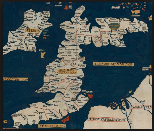
Woodcut of a reconstruction of Ptolemy's Insula Britannica and Hibernia, 1482

Woodcut of a reconstruction of Ptolemy’s Insula Britannica and Hibernia, 1482

Ptolemy divided the country up according to the Celtic tribal settlements, with present-day Somerset – according to him – largely inhabited by the Belgae. Their towns were Iscalis, Aque Calide and Venta Belgarum. Venta Belgarum was Winchester, Aque Calide obviously Aquae Sulis, or Bath; but where was Iscalis?

And answers were there many, only one of which can be correct.

Ptolemy ordered his text by tribal areas starting in the north and moving south, and I think the towns of each tribe are mainly given moving from west to east. So we might conclude from Iscalis-Aque Calide-Venta Belgarum that Iscalis was to the west of Bath, as Bath is to the west of Winchester. But how far to the west? The coordinates aren’t very helpful. This will need a closer look at the map, which I’ll take next time.