Antonine Itinerary XIV 4): Cunetio to Calleva, via Spinae

Doubts are sometimes expressed as to the location of Spinae, the penultimate station of Iter XIV. Is it Speen, Berkshire, on the outskirts of Newbury, Spone in Domesday?

Domesday entry for Speen,Berkshire

The Nottingham toponymists consider the origin of the name to be unclear, ‘possibly, ‘wood-chip place’, from spōn (Old English), a chip, a shaving of wood; perhaps also a wooden shingle tile’. They make no mention of Spinae which in Latin would mean thorns, not woodchips.

There may also have been lingering doubts on account of the fact that no Roman settlement has been discovered at Speen, unlike at Isca, Venta, Aquae Solis, Verlucio, Cunetio – and the final station, Calleva (Silchester), main centre of the Atrebates.

Calleva Atrebatum: the east-west road leads on to Speen, Cunetio, Corinium and Glevum

The earliest recorded name for Speen seems to be Spene, perhaps of the 9th century; though intriguingly, the twelfth and thirteen centuries yield Spenes, Spienes and Spenis which look like plural forms, as is Spinae. Faute de mieux, the identification stands. In any case, it is not here so much a matter of identifying Spinae as on checking how accurate the Itinerary is overall in its measured distances.

Do the distances correspond with those given by the Itinerary? Spinae was supposedly midway beween Cunetio and Calleva, xv mpm, or 22.2 km from both; so Cunetio to Calleva is therefore roughly 44.4 kms: how accurate are the Itinerary‘s distances? The conjectural (another variable) road from Cunetio-Spinae-Calleva is, indeed, about 44.5 kms.

However, the two sections are not quite equal: Cunetio to Speen, following Margary 53, is nearer 25 km, whereas Speen to Calleva is barely 20 km.

Thatcham, a little further on from Speen on the main road, has also been suggested as being Spinae. There was seemingly a small Roman settlement there – and even now a ‘Roman Way’. However accepting that suggestion would increase the Itinerary‘s discrepancy, adding about 5km to Cunetio to Speen/Thatcham, making it about 29km; and removing  5km from Thatcham/Speen  to Calleva, making that about 15km. That looks out of keeping with the general accuracy of the Itinerary.

The individual sections so far considered (note, the distances Venta-Abone-Traiectus-Aquae Solis have so far been omitted for later consideration) are recorded in the Antonine Itinerary as totalling 109.52km, while the conjectural road route would be 106 km. That is impressively close. Only one stage (Verlucio to Cunetio) falls significantly short of the Itinerary‘s distance, and is the main reason for the overall discrepancy. Strange, since the route from Verlucio to Cunetio seems very ‘straight forward’ and therefore could have been expected to be very accurate:

The route corresponding closely with Margary 53. Click to enlarge.

These results suggest the Itinerary was accurate, discounting the many imponderables and small compensating discrepancies, to within a very few kilometres. So, to the final puzzle: what of Abonae and Traiectus?
Antonine Itinerary XIV: 3) Verlucio to Cunetio

This stage is the longest one on Iter XIV – xx mpm – and therefore the one to test any theories about the accuracy of the Itinerary‘s distances most severely. Like the two stages just previously considered, the stations where this stage begins and ends have been pretty firmly identified,  Verlucio as Sandy Lane in Wiltshire, which stands on the site of the Roman road designated Margary 53; at the other end, Cunetio stood just south of Mildenhall (My-null), near Marlborough.

Time Team artist’s impression of the Cunetio mansio

If you can bear the Time Team banter, their episode on the archaeology of Cunetio is here and is interesting because they identified a 2nd-century mansio. Mansiones were travellers’ ‘coaching inns’, in settlements near the main roads, where there would be food and accommodation, and where horses could be changed – an additional sidelight on the Itinerary‘s Cunetio.

The archaeologists speculated that Cunetio might have been a Roman tax collection centre (perhaps explaining the huge hoard of 55,000 Roman coins found there); and perhaps a market town, where agricultural produce from the area would be brought in to be sold.

The site is alongside the River Kennet which presumably gave its name to the Roman town. A 10th-century source names the villages of East and West Kennet, just under 10 miles down river, as Cynetan.

Early Ordnance Survey maps trace the Roman road from just outside Bath through to Sandy Lane (Verlucio), then passing  south of Beckhampton and on to Silbury Hill where a Roman village was discovered in 2007. The track is lost here, though it points to a route straight through Marlborough on a line which which would lead directly to the site of Cunetio, still roughly corresponding to Margary road 53.

The site of Verlucio lies just at the point where there is the slight dip southerly at Chittoe, so the route from Verlucio to Cunetio is as clear as it can be, visible or guessable, the road distance measuring c.24.8km. It is as near direct, Roman road style, as it could be, so as the crow flies it is a similar distance, 24km.

OS map: the site of Verlucio, close to the Roman road

However, the 20 mpm of the Antonine Itinerary would be 29.6 km so there is some discrepancy there. Either it was measured inaccurately, or the manuscript tradition could be corrupt, recording xx mpm for xv mpm (22.2km) for example.

Antonine Itinerary XIV: 2) Aquae Solis to Verlucio

This section of the iter is one of the most straightforward: signs of a Roman road are distinguishable at least from Bathford, just east of Bath. This is the Margary road 53 which carries on to Verlucio/Sandy Lane and beyond in an almost straight line. As a result, the ‘as the crow flies’ distance is virtually the same as the road route. From the satellite view the line of the road can be made out by the stright line forming the division between the fields.

Red dots are just below the route of Margary road 53, indicated by the field boundaries. Click to enlarge.

As on Margary 53, the road seems to dip southwards near the supposed site of Verlucio, and then continues east to Cunetio. The ‘as the crow flies’ distance between Aquae Solis and Verlucio is 22.43 km, as against the possible road route from the very centre of Bath, which would be about 23 km. The Itinerary‘s  15 x 1.48 = 22.2 km is close.

Like Caerleon to Caerwent, where there is a predicted,  direct Roman road, the Itinerary is fairly accurate; on this stage very accurate.

And so to the stage between Sandy Lane/Verlucio and Mildenhall/Cunetio …


Tracing the narrative back: Countisbury = Cynuit

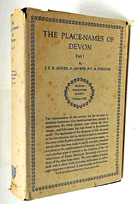
Screen Shot 2016-04-19 at 16.21.55Having now consulted the’ oracle’ of Gover et al., PNDevon, pp 62 -63, it’s difficult to know how to approach this. Scholarly publications such as  Alfred the Great, Keynes and Lapidge, 1983; The Defence of Wessex, Hill and Rumble, 1996; and A Dictionary of British Place Names, AD Mills, 2003, rev 2011, raise no doubts over the identification of arx Cynuit with Countisbury, and reference Gover et al. as evidence.

First, it is to be noted that Gover et al., PNDevon was published in 1931-32, which doesn’t automatically make it unreliable. I just mention it: the English Place Name Society’s publications are considered to be ‘definitive’, but this is now more than 80 years old.

But second, the Countisbury article opens with the sentence:  “Plummer was probably right [ … ] in identifying this with the arx Cynuit of Asser … ” Only ‘probably’? So Gover was more equivocal than recent works would imply?

On phonology: Gover quotes Ekwall’s River Names (1928) where as an example Cound Brook, Shropshire, derives from Domesday Cuneet, with several attested 13th-c. forms (Cunet, Cunette, Cunethe, Cunede &c). Ekwall thinks them very likely [sic] to be from Old Welsh Cunēt from British Cunētiō. The vowel change [to –ou-] ‘seems to be late’, he says.

Cound brook

Cound Brook, Shropshire

But the Domesday form of Countisbury is Contesberie. There is no similar early form with –unet-, ante- or post- Domesday. And since we’re not considering orthography but phonology/phonetics, it may be relevant that Cound (Brook) is pronounced Coond.

What the evidence so far shows is that Cynuit/Cunetus could, phonologically, give a form such as Count[isbury]. That is, if (but only if) Countisbury is derived from Cynuit,  the phonology could be matched by this example; but we don’t know that it’s derived from Cynuit: it’s what we’re trying to prove. And because Cuneete gives Cound, that doesn’t mean that, of necessity, Countisbury must derive from Cuneet[sberie], or some such form. It suggests that it could.

So – if A, then B is a possibility. But A is exactly what we don’t know and can’t assume.

Ekwall is discussing British river names – Cound having the same derivation as  (the river) Kennet. East Kennett,  a village close to the Kennet (and to Roman Cunetio), was (æt) Cynetan in the 10th c. and Chenete in Domesday – neither form resembling Contesberie. And as Stevenson had pointed out, there is no sign of a river or stream near Countisbury with a similar name (the Lyn seems the only nearby watercourse, Lynton being Lintone in Domesday).

Gover deals with this snag by deciding that ‘the name Cunet here must denote a hill’. Because there’s certainly a hill at Countisbury (in fact there are two: Butter Hill, to the north, is slightly higher and marginally closer to the settlement of Countisbury than Wind Hill). It would then, says Gover, be related to Welsh cwn, ‘height’; the final -et remains unaccounted for. So arx Cynuit would have meant no more than ‘the stronghold on the hill’?

Verdict: Gover et al may be right, but the tantalising bit of the jigsaw is missing: a Saxon or Domesday or medieval version of Countisbury resembling Cynetan, Cuneetsberie, Cunedesberie – which one might have expected, given the early forms of Cound and Kennet(t).

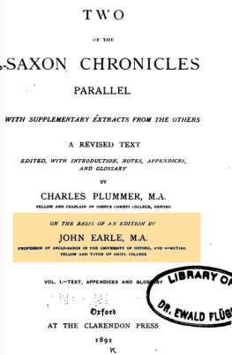
Plummers EarleOne further point, on which Gover is mistaken: he says ‘Plummer was probably right’. This was Charles Plummer, the historian, who revised an edition of Two Saxon Chronicles (the Parker and Laud versions of the Anglo-Saxon Chronicle), published in 1892. But the original editor was the Anglo-Saxon scholar John Earle, who had published his Two Saxon Chronicles in 1865; and it was he who had first suggested Countisbury – as a possibility.

Earle was considering William Camden’s  musing on whether arx Cynuit might have been Chulmleigh, near Bideford (‘An verò Chimleigh illa sit Kinuith castrum cuius meminit Asserius, non facilè dixerim, Britannia, first ed. 1586).

Earle (a South Devon man) commented: ‘A far more probable spot appears to me to be ‘Countesbury’ near Linton; and possibly if an elder form of the name could be found, it might approach nearer to ‘Cynuit’.’

Emphatically yes, on both points here: Countisbury seems more probable than Chulmleigh (Domesday Calmonleuga); and an ‘elder form of the name’ would be good evidence – but that elder form has not yet come to light. Has it?

Phonologically yours (1b)

I’ve now discovered a very useful website: Nottingham University’s Key to English Place-names. This is much more cautious about the derivation of  Countisbury than AD Mills who simply quoted arx Cynuit c. 894 (that’s Asser).

The problem is that when the historians were looking for somewhere on the Devonshire coast that might have been the site of the ‘Battle of Cynuit’, they fixed on Countisbury as the possible place, due to its situation and the similarity of the name; the place-name specialists then took the modern name as deriving from Cynuit, because that was ‘where the battle took place’. That was the wrong way round: if the specialists had first derived Countisbury from Cynuit on existing documentary evidence, then the historians could have come along and said, ‘Well, that solves the mystery of where the battle took place, then.’

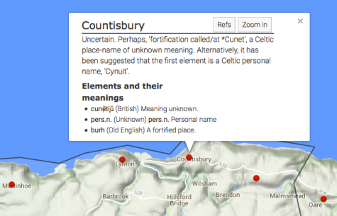
Anyway, the Nottingham site says of Countisbury’s derivation: “Uncertain. Perhaps, ‘fortification called/at *Cunet’, a Celtic place-name of unknown meaning. Alternatively, it has been suggested that the first element is a Celtic personal name, ‘Cynuit’.”

Notts UnivSo the elements are explained thus: a British placename cunẹ̄ti̥ū, meaning unknown;  a (Celtic) personal name (Cynuit?); and burh (Old English), fortified place.

But where did this ‘Celtic place name’ *Cunet’/cunẹ̄ti̥ū come from? It resembles the personal name Cunetus, found in the medieval document referring to Cuneti confessoris as the patron saint of Llangynwyd in Glamorgan, where the original form would appear to be the British/Welsh/Celtic Cynwyd or Cynuit; the later Cunetus is probably a late/neo-Latin back formation; but this is the personal name, not a place name.

It looks like the Roman place name Cunetio, which according the Antonine Itinerary (3rd c. AD) was some 35 Roman miles from Bath and has been uncovered by Mildenhall in Wiltshire. The origin was the British/Celtic name of the river on which the Romans built their town – now the River Kennet. This river name may well be represented as having been something like *Cunet’/cunẹ̄ti̥ū in Roman times. But Cunetio is nowhere near Countisbury.

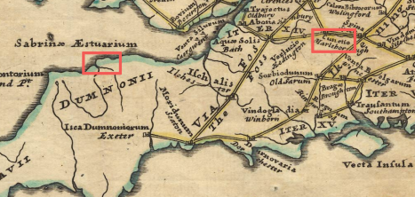
William Stukeley's 18th-c. reconstruction of the Antonine Itinerary (Iter XIV); rectangles mark Cunetio and Countisbury

William Stukeley’s 18th-c. reconstruction of the Antonine Itinerary (Iter XIV); rectangles mark Cunetio and Countisbury

There are several river names with the Celtic element Kenn or Kennet, but they aren’t near Countisbury either. It does seem as if this *Cunet’/cunẹ̄ti̥ū would, phonologically, give Cynuit – but there is still nothing to link it to Countisbury.

As I see it, the Nottingham site is more circumspect regarding the derivation – which leaves us … where we were.